


Duncanville Fire Dept, Tuscaloosa County, Alabama
About
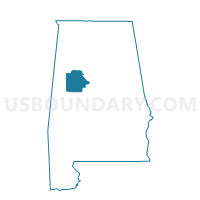
Outline

Summary
| Unique Area Identifier | 522989 |
| Name | Duncanville Fire Dept |
| County | Tuscaloosa County |
| State | Alabama |
| Area (square miles) | 89.86 |
| Land Area (square miles) | 89.61 |
| Water Area (square miles) | 0.25 |
| % of Land Area | 99.72 |
| % of Water Area | 0.28 |
| Latitude of the Internal Point | 33.06369460 |
| Longtitude of the Internal Point | -87.41475000 |
Maps


Graphs
Select a template below for downloading or customizing gragh for Duncanville Fire Dept, Tuscaloosa County, Alabama


Neighbors
Neighoring Voting District (by Name) Neighboring Voting District on the Map
- Alternative School-2, Bibb County, AL
- Coaling Community Center, Tuscaloosa County, AL
- Cottondale Methodist, Tuscaloosa County, AL
- Eoline Fire Dept-3, Bibb County, AL
- Eoline Fire Dept.-12, Bibb County, AL
- Frierson-Big Sandy Baptist Church, Tuscaloosa County, AL
- Hillcrest High School, Tuscaloosa County, AL
- McFaland Mall, Tuscaloosa County, AL
- Phipps Work Center, Hale County, AL
- Skyland Oaks Retirement Center, Tuscaloosa County, AL
Top 10 Neighboring County Subdivision (by Population) Neighboring County Subdivision on the Map
- Tuscaloosa CCD, Tuscaloosa County, AL (116,662)
- Centreville-Brent CCD, Bibb County, AL (12,937)
- Big Sandy-Duncanville CCD, Tuscaloosa County, AL (9,260)
- West Blocton CCD, Bibb County, AL (8,757)
- Coaling-Vance CCD, Tuscaloosa County, AL (7,678)
- Moundville CCD, Hale County, AL (3,534)
Top 10 Neighboring Place (by Population) Neighboring Place on the Map
Top 10 Neighboring Unified School District (by Population) Neighboring Unified School District on the Map
- Tuscaloosa County School District, AL (105,218)
- Tuscaloosa City School District, AL (89,438)
- Bibb County School District, AL (22,915)
- Hale County School District, AL (15,760)
Top 10 Neighboring State Legislative District Lower Chamber (by Population) Neighboring State Legislative District Lower Chamber on the Map
- State House District 63, AL (59,073)
- State House District 62, AL (55,022)
- State House District 49, AL (52,014)
- State House District 72, AL (39,414)
- State House District 70, AL (39,253)
Top 10 Neighboring State Legislative District Upper Chamber (by Population) Neighboring State Legislative District Upper Chamber on the Map
- State Senate District 14, AL (168,669)
- State Senate District 21, AL (140,682)
- State Senate District 24, AL (118,832)
Top 10 Neighboring 111th Congressional District (by Population) Neighboring 111th Congressional District on the Map
Top 10 Neighboring Census Tract (by Population) Neighboring Census Tract on the Map
- Census Tract 100.04, Bibb County, AL (8,767)
- Census Tract 107.02, Tuscaloosa County, AL (7,684)
- Census Tract 107.01, Tuscaloosa County, AL (6,568)
- Census Tract 123.05, Tuscaloosa County, AL (4,243)
- Census Tract 108.02, Tuscaloosa County, AL (3,825)
- Census Tract 125.03, Tuscaloosa County, AL (3,824)
- Census Tract 400, Hale County, AL (3,534)
- Census Tract 100.01, Bibb County, AL (2,732)
Top 10 Neighboring 5-Digit ZIP Code Tabulation Area (by Population) Neighboring 5-Digit ZIP Code Tabulation Area on the Map
- 35405, AL (37,661)
- 35453, AL (11,127)
- 35474, AL (6,180)
- 35184, AL (5,841)
- 35034, AL (5,541)
- 35456, AL (3,759)